Space Weather Applications
- Low Earth Orbit Satellite Drag - European Space Operation Centre (ESOC)
- Geomagnetically Induced Currents (GIC) - Scottish Power plc
- Directional Drilling for Oil and Gas - A Consortium of Drilling Companies and Operators
Low Earth Orbit Satellite Drag - European Space Operation Centre (ESOC)
BGS has been involved with ESOC for over ten years, in the field of predicting geomagnetic and solar activity. Software has been developed for predictions of data on two times scales: at daily intervals of one to twenty-seven days ahead, and at monthly intervals of one month to a solar cycle, or longer.
We quantify solar activity by the solar radio emission at 10.7 cm wavelength, known as F10.7, and we quantify geomagnetic activity using the mid-latitude activity index, known as Ap.
ESOC are interested in predictions of these data as they are used in models of upper atmospheric density . These models can be used to estimate the frictional drag on low-earth orbit satellites in the thermosphere. Drag matters because it affects the lifetime of satellites in orbit, for example, because of the use of on-board fuel or gas to reposition the satellite on track. Drag variability can be particularly important for high-accuracy science missions, e.g. the ESA ERS and Envisat Earth observation satellites.
Variable solar ultraviolet emission causes heating and expansion outward of the atmosphere (thermosphere). This increases frictional drag. Geomagnetic activity also affects the atmosphere, particularly during geomagnetic storms and at high latitudes. Enhanced currents flow in the ionosphere, driven by magnetospheric processes, and cause 'Joule heating', much like the current through an electric bar heating element. This also causes the atmosphere to expand outwards.
Our daily forecasts of F10.7 and Ap as well as our long-term activity forecast can be found in Predicting Space Weather at BGS.
Further details on our studies into forecasting solar and geomagnetic indices and in the relationship of indices to atmospheric drag in the thermosphere are given in "Improved Predictions of Solar and Geomagnetic Activity with Application to ESA/LEO Satellite Operations" 405kB pdf. We describe here how we have used both neural networks and linear autoregressive models of solar and geomagnetic activity. We also quantify how accurate our daily forecasting tools have been over the last ten years of operational use at ESOC and how they have been improved (in 2003). We have also investigated how measured drag on low Earth orbit satellites correlates with solar and geomagnetic indices and how linear correction factors for density models may be developed using these correlations.
Geomagnetically Induced Currents (GIC) - Scottish Power plc
BGS has worked with Scottish Power on GIC risk. Scottish Power was the local grid operator for Central and Southern Scotland, covering the bulk of the population centres in Scotland. This is now looked after by National Grid. Our partnership had three components.
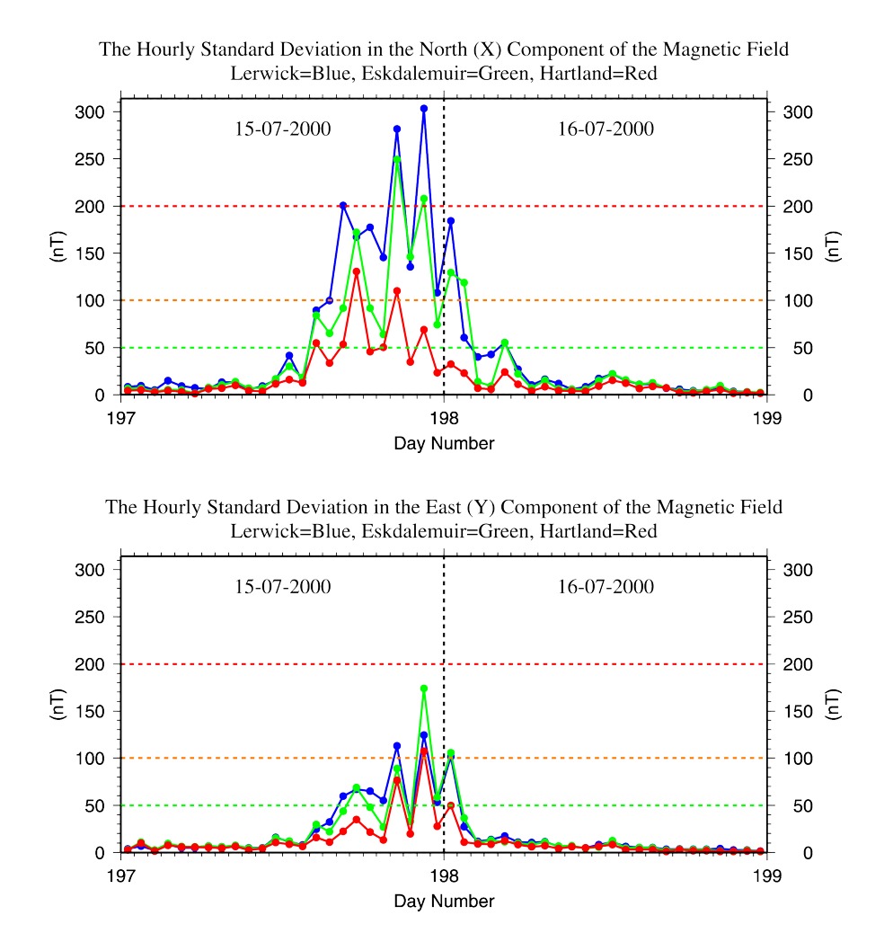
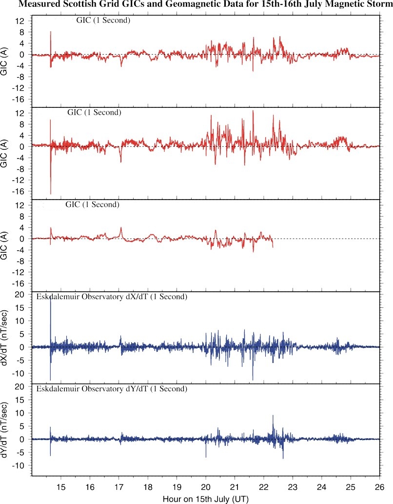
Firstly, we supplied near real time geomagnetic data to the grid control centre. This was used to identify whether any near-DC in the grid and in transformer earths is of geomagnetic origin. The geomagnetic data were supplied by highly reliable links from BGS in Edinburgh and, as an independant backup, directly from the UK observatories. We use the hourly standard deviation (HSD) in the horizontal magnetic components to detect those rapid variations that drive surface electric fields across the UK and hence GIC in the power grid. The grid operators used this HSD index, as part of their wider environmental and system data collection, to ensure the continued safe operation of the power grid.
The second element of our partnership was a daily forecast of global geomagnetic activity, using an analogue of the Ap index, calculated noon to noon (UT). Our forecasts covered the interval noon to noon, up to three days ahead and are issued by mid-day, each working day (and at weekends during known 'risk' periods). This time frame is appropriate for the UK, as most geomagnetic activity tends to fall in the night time hours, often across midnight, and a standard daily index might therefore not capture all the activity in a single event. We also try to relate the expected global activity to local conditions, via the possible ranges of HSD. Forecasts were made with recourse to our automated forecast tools as well as public domain data worldwide.
Thirdly, GIC measurements made by Scottish Power and the geomagnetic data collected by BGS has resulted in a valuable and growing database for exploring GIC and the geophysical properties of the UK landmass and its continental shelf and seas.
We have made a number of academic studies of GIC in
relation to geomagnetic data. For example, "Monitoring
Geomagnetically Induced Currents in the Scottish Power Grid" 239kB pdf describes the main elements of the monitoring and prediction activities
for Scottish Power. An earlier study for the National Grid of England
and Wales gave rise to "Geomagnetically
Induced Currents in the UK: Geomagnetic Variations and Surface Electric
Fields" 1.1MB pdf
We later extended our activities further by adding new features to this service and we communicated these new results to Scottish Power in near real time. The new features were:
(1) an automatic detector of shocks in the solar wind, indicating the probable arrival of a coronal mass ejection from the Sun and the increased likelihood of a geomagnetic storm,
(2) a tool for estimating the level of GIC risk in the Scottish power grid, based on combining a power grid model, a UK surface electric field model and an inducing geomagnetic source field model.
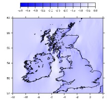
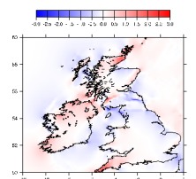
An example of model UK surface electric fields that result from an inducing east-west ionospheric electrojet are shown below. Coupled with a power grid model, we can use such electric field distributions to calculate GIC in the grid.
A description of some of these ideas was given in a talk, "Monitoring and Analysis of Geomagnetically Induced Currents in the British Isles" 416kB pdf, given at a ESA/ESTEC space weather meeting. Information on this ESA/ESTEC 'pilot project' is available: "Solar Wind Monitoring and Induction Modelling for GICs (SWIMIC)" 19kB pdf
Directional Drilling for Oil and Gas - A Consortium of Drilling Companies and Operators
BGS supplies Interpolation In-Field Referencing (IIFR) services in real-time (1.5MB pdf). This is a method for determining the geomagnetic field on a minute-by-minute basis at a drilling site where magnetic survey tools are being used for navigating well-bores. It uses data from nearby observatories. The method also takes account of the other main sources of the field: the local crustal field, the field from fluid motions in the Earth's core and the steady-state magnetospheric field. A consortium of drilling companies and operators supports this work.
Papers on the space weather aspect of our service to the oil and gas industry can be found at "Space weather effects on drilling accuracy in the North Sea" (published in Annales Geophysicae in 2005) and at "Space weather services for the offshore drilling industry" (225kB pdf) (ESA space weather meeting in 2001).
- Global Geomagnetic Models
- Space Weather and Geomagnetic Hazard
- High-frequency magnetometers
- Schumann Resonances
- Geoelectric field monitoring
- Space Weather Impact on Ground-based Systems (SWIGS)
- SWIMMR Activities in Ground Effects (SAGE)
- Geomagnetic Virtual Observatories
- Quantum magnetometers for space weather
- Magnetotellurics
- Publications List
